Trail Walking Scots Bay - Wikiloc - Cape Split - Photo
 Alizée.pee
Alizée.pee

User GUIDE

© OpenStreetMap contributors
Length
Length
12.4 km
Max alt
Max alt
150 m
Uphill gradient
Uphill gradient
259 m
Km-Effort
Km-Effort  
15.8 km
Min alt
Min alt
22 m
Downhill gradient
Downhill gradient
253 m
Boucle
Boucle
Yes
Creation date :
2019-08-23 13:37:52.327
Updated on :
2019-08-23 13:40:33.721

(0 Reviews)

Walking
Walking
3h24
Difficulty : Difficult

Scan this QR Code to open this trail in the SityTrail application

FREE GPS app for hiking

Logo SityTrail SityTrail

IGN / Geographical institutes

Download SityTrail from the App Store Download SityTrail from Google Play

Logo SityTrail SityTrail World

The world is yours!

Download SityTrail from the App Store Download SityTrail from Google Play Download SityTrail on Huawei AppGallery

About

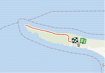
Trail Walking of 12.4 km to be discovered at Nova Scotia, Municipality of the County of Kings, Scots Bay. This trail is proposed by Alizée.pee.

Description

Sentier qui ne présente pas de grosses montées mais possède des vues imprenables sur l'océan. Il vous emmène jusqu'à la pointe du cap, endroit parfait pour manger un morceau. De là, il vous sera possible d'admirer les formations rocheuses qui sortent de l'eau ainsi que la beauté de deux courants océaniques qui se rencontrent.

Elevation profile

Positioning

Country:
Canada
Region :
Nova Scotia
Department/Province :
Municipality of the County of Kings
Municipality :
Scots Bay
Location:
Unknown
Start:(UTM)
387783 ; 5018963 (20T) N.

Trails nearby


Close
My subscriptions